Columbus, Ohio USA
Return to Homepage www.shortnorth.com
Summit and Fourth
One-way or two-way? Street safety fuels debate
By Tracy Zollinger Turner
May/June 2015 Issue
Return to Homepage
Return to Features Index
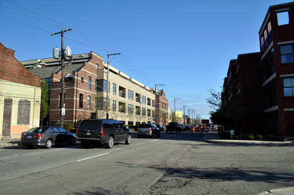
A stream of cars head north on Fourth Avenue from downtown passing construction in Italian Village that will soon bring a large influx of residents and pedestrians to contend with hazardous conditions. Photo by Tracy Zollinger Turner Summit and Fourth: More pedestrians are coming to these major thoroughfares, as are bike lanes and fewer lanes of traffic. How safe will it be?
When Interstate 71 was being built in the 1950s, Summit and Fourth streets were converted into one-way thoroughfares to ease the growing traffic congestion north of the city. It was intended to be a temporary measure. The multiple car lanes of one-way streets, paired with infrequent traffic lights or crosswalks, cue drivers to move quickly through densely populated neighborhoods. In a time when the number of pedestrian traffic deaths has been increasing nationally, critics of the one-way structure are asking whether it’s time to talk about a change. There have been dozens of public conversations about returning them to a two-way configuration over the last 65 years, but none ever gained any traction.
There will be other significant changes in both streetscapes this year, however. The development of Jeffrey Park will bring 1,300 new residences to Fourth Street, filled with people who will presumably be crossing it (as well as Summit) to walk into the heart of the Short North on a regular basis. The streets will also both be repaved and repainted, reducing traffic by a lane to accommodate new bike lanes that are being added from Fulton Street downtown all the way north to Hudson Street. (The resurfacing plan: http://columbus.gov/US23Resurfacing/)
Matt Adair, a masters student in city and regional planning at Ohio State University, and volunteer with the Weinland Park Community Civic Association, has been working on an independent study about Summit and Fourth and has created a Facebook page called “Make Summit & 4th Street ‘Go Both Ways.’” Despite having been told by many that his campaign is likely an exercise in futility, especially since commuters have become so dependent on these streets, he continually posts a vast amount of information about traffic calming measures the city could take, often digging up old studies about safety and mobility, quotes where civic leaders pulled for it in the past, and news from other cities that have found strong economic development on similar streets that were converted. He also lives between the two thoroughfares.
“It’s a highway running through the neighborhood – 85 percent of drivers are traveling between 37 and 47 miles per hour,” says Adair. “That’s definitely an issue on a neighborhood street lined with churches and schools and homes.”
“All of the other major neighborhood streets are two-way. These streets are an anomaly. These are the only streets that haven’t been converted in the city. You can have a walkable street and have high traffic capacity. Two-way configuration doesn’t necessarily mean less traffic can move through.”
Neil Avenue, he points out, with its two-way structure, “visual envelope” of trees and medians manages close to 12,000 cars a day compared with the nearly 12,500 that travel Fourth and nearly 13,500 that travel Summit, according to studies by the Mid-Ohio Regional Planning Commission (MORPC). East North Broadway handles over 16,000 cars a day, West Lane Avenue over 17,500 cars. According to the University District Plan from the city’s Department of Development (adopted in February of this year), Hudson handles over 23,000 cars a day as a two-way street, and High Street over 31,000.
Adair recently presented to the Italian Village Society’s Streets Committee, where safety concerns about what the pedestrian influx the Jeffrey and other residential and business developments along Fourth and Summit will bring to the busy street are substantial.
Why is a neighborhood street designated as a federal highway? When and why did this happen, and how can we solve this?
- Matt Adair“My concern with the whole one-way versus two-way question is that it’s kind of like putting the cart before the horse,” says Andy Klein, chair of the Italian Village Streets Committee. “The problem is the need for traffic calming. At least when its one way there are periods of quiet when you can cross the street.”
The repaving project will be the most significant shift to come in a long time, with both streets set to be reduced by a lane, have slightly narrower lanes for cars in areas and a new painted bike lane (which becomes a protected two-way bike lane north of 11th up to Hudson).
Klein and Adair do agree that there aren’t enough pedestrian safety measures built into the street paving project.
“The street has been narrowed,” says Klein. “But we need to look at bump-outs and crosswalks with pavement treatments and trees – how do we visually narrow it for drivers to make it less of a freeway… how do we effectively calm traffic?”How much can the bike lanes slow things down?
“When you add bike facilities, you make motorists more aware and you tend to slow traffic down,” says Rick Tilton of the Columbus Department of Public Service. “So it does have a traffic calming effect.”
Yay Bikes!, the advocacy group for more and safer cycling in Columbus, had a hand in the development of the lanes. According to executive director Catherine Girves, Yay Bikes! persuaded engineers from the Department of Public Service to ride the corridor with them.
“It was incredible,” she says. “They were able to see things from the perspective of the street so they were able to really see what worked and what didn’t according to their design. They were pulling out their Sharpies and making changes there and then.”
Many cyclists were concerned that the bike lane will not be protected in and closer to downtown. But there will be other visual measures in place, like “turn boxes,” which create painted visual cues for cyclists (and drivers) to facilitate some of the bigger lane-crossing navigation challenges.
“I’m a really experienced cyclist, and I’m going to travel Summit Street no matter what because that’s how I like to travel,” says Girves. “But there are plenty of people who are less experienced cyclists who would not be comfortable crossing three lanes.”
There is also a commitment from the city to clean and plow the bike lanes, says Girves. She says when bike lanes were painted at Ohio State University in the 1980s, the lack of maintenance kept them from being successful Tilton says that creating the bike lanes, which support more mobility in the city for people who cannot afford cars, ends any discussion of making Summit and Fourth two-way.
“You would lose a whole bunch of parking and couldn’t put bike lanes on the streets,” he says.
In places, the plan calls for some of the car lanes to be reduced from (effectively) 14 feet to 12 or 11, which is also supposed to be a traffic calming measure.
“Creating skinnier lanes actually slows traffic,” says Girves, noting that she spent three decades in the university area. “I was always a huge advocate for calming traffic and making things safer, but I would often notice when I was on those streets (Summit and Fourth) that I was traveling too fast, but the psychology of driving on lanes that wide does encourage faster travel.”
Adair, who says the bike infrastructure “is awesome,” feels that the car lanes should be smaller still to really have an impact, and in looking at the lanes of the new plan (which do vary because Summit and Fourth are not a consistent width from I-670 to Hudson) there are areas where lanes are widening by a foot. According to the National Association of City Transportation Officials (NATCO), the recommended lane width for urban streets is 10 feet to improve safety for all users.
“Narrower streets help promote slower driving speeds which, in turn, reduce the severity of crashes,” the NATCO site reports. “Narrower streets have other benefits as well, including reduced crossing distances, shorter signal cycles, less stormwater, and less construction material to build.”
When he asked an engineer, Adair says he was told that, because the two streets are a designated part of U.S. 23, which is a federal route, lane size is restricted to a minimum of 12 feet.
“Why is a neighborhood street designated as a federal highway?” Adair asks, noting that adhering to policies from a bygone era may be part of what is preventing the city from puzzling out a solution that could include two-way traffic and a protected bike lane. “When and why did this happen, and how can we solve this? It is disappointing that we are stifled by antiquated traffic engineering policies that neglect the needs of non-motorized users in the densest and most walkable part of the entire city, and the densest area of the entire state.”
Even though resurfacing changes are forthcoming, discussions about the future of Summit and Fourth streets could, in some ways, just be beginning. Columbus’ DPS has begun a citywide initiative called “Connect Columbus” to solicit feedback from the public about mobility in the city. For the next 18 month or so, information will be gathered that will inform plans for the upcoming decades. There are workshops being held in different parts of the city that are open to all whether they can participate for “ten minutes or two hours,” says Tilton. There is also a “Plan Van” set to collect public input at summertime markets and events. The website has a full schedule and a place for written feedback: www.columbus.gov/ConnectColumbus/
“I am telling everyone about the Connect Columbus project,” says Girves. “Every 30 years the city has sat down and written a 30-years plan about the streets. That’s what this moment is. The next year is the moment to weigh in and make sure that street design over the next 30 years is what is really good for the neighborhoods and not just the people driving through them to get from one place to another.”
The tension over the roads’ futures lies between people who live in the neighborhoods they cut through and commuters heading downtown.
“The further north you go, the more likely you are to find people in favor of keeping them a one-way pair,” says Klein. “People controlling the streets work downtown and have a commuter attitude. If someone lives in Weinland Park, maybe they are more sympathetic to the neighborhood not being used as a thruway.”
From Adair’s perspective, the city has been beholden to decisions made in a period of history when suburban commuters were trying to move through urban communities as quickly as possible for too long.
“The sentiment in the 1950s was not to accommodate pedestrians, it was to accommodate cars,” says Adair. “It’s about saving time. But how much is your time worth? Is it worth sacrificing the high quality of life in six neighborhoods?”
“People are telling me I’m wasting my time doing this. I’m interested, I’m passionate, I’m learning. That’s not wasting my time. This is my way of trying to get people to think critically about the safety issue.”
To Klein, the Connect Columbus initiative could create an opportunity for Summit and Fourth to be testing grounds for traffic calming measures that could help other parts of the city with pedestrian safety.
“I would love to have Summit and Fourth be the poster children for what could be a city-wide effort,” says Klein. “We have made incremental progress.”Adair’s Facebook www.facebook.com/gobothways. Connect Columbus project is at www.columbus.gov/ConnectColumbus/
This article was reported with support from Puffin Foundation West., Ltd. © 2015 Short North Gazette, Columbus, Ohio. All rights reserved.
Return to Homepage www.shortnorth.com